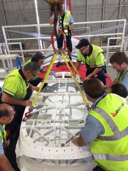
Qantas engineers installing a new antenna on their Boeing 737-800. Photo: Qantas Airways
Qantas A330 and 737 pilots are in the midst of evolving their flight operational data visualization strategy. Software upgrades added to the existing wireless aircraft interface devices on those models will bring the airline into a new era of connected iPad functionality.
Avionics International recently caught up with Peter Alexander, manager of technical programs at Qantas Airways, to discuss how the airline has been upgrading its fleet of A330s and 737s to provide its pilots with access to real time turbulence alerting.
Right now, the Australian carrier is completing installations of hybrid Ku/Ka-band antennas to enable access to ViaSat’s Ka-band and Australian domestic broadband provider NBN’s Ku-band satellite networks throughout the continent of Australia.
The aircraft interface device (AID+) that Qantas has upgraded to features a wireless router, ACARS proxy service and ARINC 429/717 aircraft parameter streaming via port based application programmable interfaces. Inside the cockpit the AID+ enables communication between the wireless iPad applications used by pilots and the embedded ARINC 429 data streams. It also links pilot apps to the internet to enable the use of web charts maps and weather.
“We have been using Apple’s iPad as an electronic flight bag for the last five years and have become very much embedded within the Apple iOS ecosystem. Being able to add the satellite connectivity to that in combination with the AID+ enables GPS own-ship capability for our pilots using Jeppesen charts. Because the AID+ is connected to the ViaSat system, we get retain general Internet capabilities as well,” said Alexander.
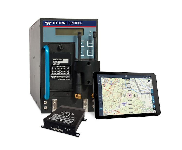

Teledyne’s AID+. Photo: Teledyne
Using iPads in combination with the avionics upgrades will also help Qantas pilots to improve their situational awareness by giving them improved access to long range weather. According to Alexander, prior to introducing the iPad, pilots were mostly limited to the 200 nautical mile visibility of weather that the weather radar on legacy aircraft are capable of.
The goal is to give pilots information about weather further out in front of the aircraft using the iPad and connectivity to visualize the Australian Bureau of Meteorology’s weather forecasting throughout all phases of flight.
Teledyne also included a software developer kit functionality within their AID+ which allows Qantas to develop their own third-party iPad applications that can communicate with the AID+.
“The software upgrade to our AID+ effectively establishes a simulator and development tool available free of charge from our website. This tool makes it very easy for airlines or third-party software developers to build and test new applications on the ground that can interface with GroundLink AID+ airborne AID. Qantas, which has a particularly strong IT function within its operation, and has been using this tool to build and test its own and third-party applications prior to deployment on the aircraft,” said Murray Skelton, director of aircraft solution strategy at Teledyne Controls.
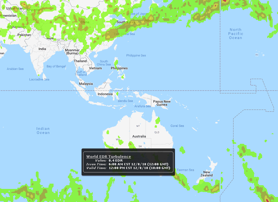

DTN’s turbulence forecasting and alerting model. Photo: DTN
The application Alexander is focused on giving pilots access to is a more advanced turbulence alerting mechanism on their iPads. The airline is working with DTN, a Minnesota-based provider of actionable visual data insights primarily through web-based application programmable interfaces.
“One of the exciting things we’re working on is in partnership with an organization called DTN that has a deeply advanced turbulence forecasting model, we have an agreement with them in place, where we’re looking to provide real time turbulence alerting inside the flight deck using ViaSat connectivity,” said Alexander.
Navigating around clear air turbulence is one of the crucial uses of connectivity sought by flight operations departments at commercial airlines globally. Delta pilots, for example, use cabin-based Gogo Wi-Fi as connectivity for an EFB app that uses algorithms developed by the National Center for Atmospheric Research.
The app allows Delta’s pilots to set threat index alerts generated from aircraft sensor data. The app’s algorithms use a combination of vertical accelerometer and atmospheric state data, including aircraft-specific behavioral data such as pitch, roll and wind speed to formulate app-based turbulence reports for pilots in real time.
At Qantas, Alexander wants pilots to be able to visualize where turbulence is located using DTN’s advanced forecasting model. DTN’s Flight Route Alerting engine requires Qantas pilots to provide their flight plans up to 36 hours in advance, and the service then generates weather-related impact alerts from our four-dimensional geospatial database throughout the duration of the flight.
Flight Route Alerting features 14 different weather parameters that users can choose from and a core flight hazard dataset within the alerting engine. These features have been enabled through DTN’s investments in developing a suite of mission-critical intelligence around weather-related flight hazards.
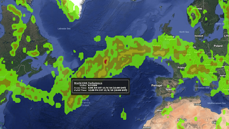

DTN’s turbulence forecasting model. Photo: DTN
They have focused on improving their forecasting models for aviation with a focus on including flight-level specific turbulence, icing, and thunderstorm forecasts, according to Wesley Hyduke, aviation product manager, DTN.
To accompany the text-based alerts generated from DTN’s Flight Route Alerting engine, Qantas is also consuming DTN’s catalog of discrete geospatial weather data so that pilots will be able to graphically view the weather content that generated the alert, Hyduke said.
Starting in the first quarter of 2019, Qantas will begin beta testing DTN’s new NowCast rapid updating short term forecasting application designed to allow aircraft dispatchers and pilots to decide on minimum-cost tactical reroutes during flight if forecast conditions change significantly.
“By providing real time turbulence forecasting for our pilots, it brings more safety and comfort to our passengers as we can optimize flight paths through and around turbulence using a graphical display of what’s happening. Turbulence reporting currently on most commercial aircraft is limited to ACARS text-based data and sometimes that’s hard to visualize with a 4D polygon how its going to impact the aircraft. By having a graphical alert through a connected EFB, it makes it much easier to understand exactly where the turbulence is,” said Alexander.
 :
: