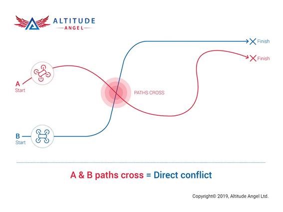
Depiction by Altitude Angel
Two companies, UK-based Altitude Angel and Google’s Wing Aviation, recently announced unmanned traffic management solutions that aim to help drone operators safely conduct automated flights beyond visual line of site — a crucial challenge facing the rise of automated drone delivery services as well as urban air mobility solutions.
Altitude Angel’s Conflict Resolution Service is an API that enables pilots or operators to check for conflicts in their drone flights against any other flight plans that have been filed, alerting operators to proximity warnings or direct conflicts and suggesting minimally-invasive changes to flight times or routes.
“Any one submitting a flight plan (to the system) will be able to see if there is a confliction with another planned flight,” Stephen Farmer, head of corporate communications for Altitude Angel, told Avionics International. “All Altitude Angel’s current customers are signed up to go live with the CRS — which will translate into some 5,000 to 6,000 flights per month feeding the de-confliction service.”
Developers and drone manufacturers can opt-in to CRS’ global conflict resolution platform to enable all flight plans to be checked against others filed with the service. “Private modes” exist for fleet operators who only want to check for conflicts against their own drones or customers, according to Altitude Angel.
“We’re bringing in commercially available data feeds of every piece of manned air traffic available today. So that’s every commercial flight, so for example police helicopters, medical choppers etc,” Farmer added. “So the tactical service will then supplement that drone-on-drone collision data [from the Strategic CRS] with drone on manned aviation.”
CRS operates in two components: Strategic CRS, which focuses on pre-flight checks as described above, is online as of July 23. Tactical CRS, which deals with unexpected changes to the airspace during flight, will launch in late September, according to Altitude Angel.
Tactical CRS will continuously monitor the airspace around an aircraft for other aerial vehicles, temporary flight restrictions and dynamic geofences. After identifying a potential conflict, the program will automatically make the necessary routing adjustments, allowing the drone to maintain appropriate separation with other aircraft and fly around restricted airspace to complete its mission.
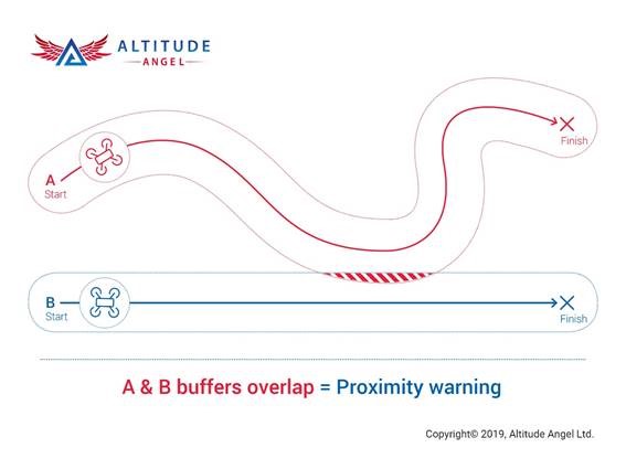

Depiction by Altitude Angel
However, unlike pre-flight planning via Strategic CRS, where a drone operator would be alerted to conflicts with existing flight plans, proximity warnings are not issued to operators if infringing flight plans are filed after theirs is submitted, Farmer clarified to Avionics.
“The launch of our Conflict Resolution Service cannot be underestimated,” said Richard Parker, CEO and founder of Altitude Angel. “It is a massive step forward, a ‘game changer’, for not only Altitude Angel, but for the future of automated flight. The ability for drones and automated aircraft to strategically plan flights, be made aware of potential conflict, and alter their route accordingly is critical in ensuring safety in our skies. This first step is all about pre-flight coordination, between drone pilots, fleet operators and other UTM companies.”
Wing also announced the launch of OpenSky, which it calls “a family of software products … [to] help users comply with rules and plan flights more safely and effectively.”
The app, released to users in Australia this month, provides drone operators with a checklist covering critical factors — including airspace restrictions, known hazardous situations and proximity to airports and heliports — when entering an area. Users will also be given alerts related to new restrictions or emergency events that may impact nearby airspace.
All of this information comes from “Australia’s Civil Aviation and Safety Authority-approved data sources,” according to Robert van Gool, a Wing spokesperson.
Wing plans to expand OpenSky beyond Australia and continue adding tools to the app suite, though the company could not give any timelines for future releases. OpenSky is currently the only CASA-approved UAS service provider in the country, according to Wing.


Want more eVTOL and air taxi news? Sign up for our brand new e-letter, “The Skyport,” where every other week you’ll find the most important analysis and insider scoops from the urban air mobility world.
 :
: