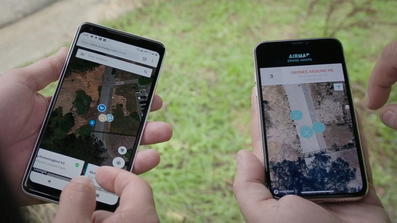
Tracking drones through AirMap’s app. (AirMap)
Three major UAS service suppliers (USS), Google’s Wing, AirMap and Kittyhawk, have teamed up to develop a distributed network for the remote identification of drones.
Called InterUSS, the solution allows agencies, companies and civilians to check the drone operations in their area regardless of which USS the drone is registered with — so long as that USS opts in to the platform. Ultimately, opting in to such a platform might not be voluntary, as remote ID for drones is a hot topic; militaries and law enforcement agencies say they need to be able to identify and track drones to be able to keep people and places safe, as well as prevent intentional or unintentional incursions into unauthorized airspace from causing incidents such as the one in London last month, where a drone’s presence at Gatwick Airport grounded several flights.
The FAA and NASA are both involved in trying to integrate unmanned traffic management (UTM) into America’s greater national airspace system, while other countries try to do the same. However, the traditional aviation rulemaking bodies are ill-equipped to deal with drones, according to AirMap CTO Andreas Lamprecht.
“Drones are developed at a speed quite different from typical aviation rulemaking cycles, so the technological capabilities are astonishing,” he said. “There’s no age restriction, anyone can order a drone online, it takes five seconds to become a pilot… and what you can do is remarkable.
“You can fly five miles away, take pictures in 4k — you can do all sorts of cool things but also all sorts of dangerous things. You can fly too close to airports, in no-fly zones, you can spy on your neighbors,” Lamprecht continued. “With any new technology, there are a number of bad things that are in theory possible to do with it, and the problem is, so far local law enforcement doesn’t have any tools to determine what is going on.”
Each of the three companies involved in developing the InterUSS platform are providers of the FAA’s Low-Altitude Authorization and Notification Capability (LAANC), which puts them in a good position to help develop such a system; LAANC providers’ ability to grant real-time operation approval in exchange for flight plans and information about drone and operator being filed with a company can serve as a building block for a more widespread network of publically accessible information such as what InterUSS is trying to achieve.
As drones make their way into everyday life, the platform is supposed to serve as a simple compromise between the need for remote ID and the desire for operator security. Through the platform, each USS has in essence approved the operator and can vouch for them while only sharing the required information about who they are to the public, not exposing them unnecessarily — but, additional information is available on file if it is needed.
Two major benefits to InterUSS are that it requires no additional infrastructure to operate and that it will support any approved drone service providers, seeking to integrate everybody’s information, according to Lamprecht.
“When you have a mobile network, you have operators and give consumers the choice of buying a sim card from different people, and different phones,” Lamprecht said. “There’s competitive market freedom.
“[We have the] same goal. An open market of UTM service providers that have [application programming interfaces] that can connect to each others and exchange information.”
To that end, Lamprecht said, an operator could have remote ID with one company and another service from another company, but still integrate it all with the InterUSS platform.
“The network would be like the Apple app store, but the role of Apple is played by the government,” Lamprecht said. “A company needs to go through a process; once companies have made it through the process to be an approved provider, they can be on the network.”
The technology enabling InterUSS’s ability to check remote IDs is the same as the technology that enables LAANC, just applied more broadly.
“We just felt that this tech can be expanded if you combine it with the work that we’ve been doing in the NASA program if we provide a solution for remote ID,” Lamprecht said.
AirMap is one of a handful of drone companies that has been working with NASA on UTM research for the last four years. Last May, the third stage of the program wrapped up, and dates of the fourth stage haven’t been revealed yet.
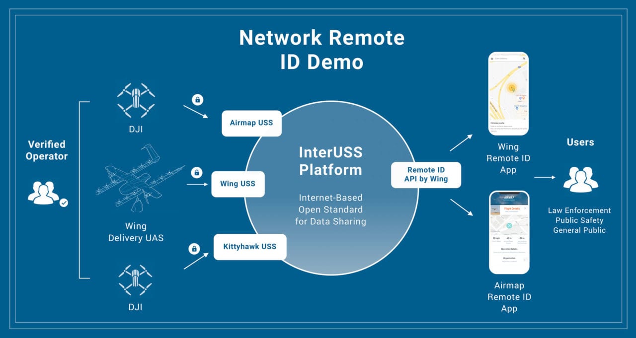

A graphic showing the flow of data using InterUSS. (Wing)
The biggest potential issue with AirMap, Wing and Kittyhawk’s solution is one of buy-in. This system doesn’t work if operators aren’t sharing their information with USS and USS aren’t registered with the InterUSS network. Right now, the network, which is not yet publicly available, consists only of AirMap, Wing and Kittyhawk’s users. Lamprecht said they don’t disclose numbers, but “it’s a fraction of [what you’d need for the app to provide a full picture] because you don’t have to use it.”
The FAA has put out a request for information (RFI) for a remote ID solution, but there are a number of potential solutions vying for acceptance.
“There’s a race to see who has the best solution,” Lamprecht said. “ADS-B doesn’t currently offer a lot of security. Chipset manufacturers are interested in maybe a disconnected or local broadcast one employing Bluetooth.”
DJI, a Chinese company that produces the vast majority of civilian-operated drones, advocates local broadcast for two reasons, according to Lamprecht: It doesn’t require a mobile network, thus allowing compatibility in more locations, and the company is a big advocate of operator privacy.
Lamprecht isn’t as concerned about the latter: He says the information shared can be as little as the drone equivalent to a license plate number or the last several positions of the drone.
The former concern is real, though: While most areas in the developed world have mobile network access, simply being unable to serve areas that don’t is a bad solution. Because InterUSS depends on a mobile network, Lamprecht sees it as a complementary, not sole, solution right now.
“We at Airmap think it will be complemented by a secondary type of remote ID that is not [dependent on a mobile network]; something like a Wi-Fi broadcast or open drone ID,” he said. “We need a regulatory framework for this. In the end, the problem that this is trying to solve is that anywhere in the world, we have all sorts of regulations that already exist for drones with very little possibilities to already enforce those rules.”
Because the integration of UTM is a global problem, AirMap wants its solution to apply globally. And Lamprecht said he sees no reason significant changes would be needed to adapt to different regions.
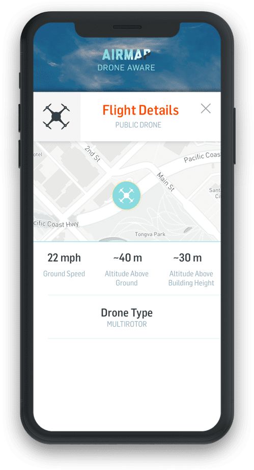

The InterUSS platform tracking a drone on a cell phone. (AirMap)
“When you fly commercial, the same aircraft work everywhere, procedures and technical standards are in sync,” he said. “Drones are the same — DJI. So, the same problems are being faced. We believe that there is really no need for doing too much of a localized technology.”
The three companies recently did a demonstration flying drones registered with each of their services, and non-participating bystanders were able to open the Airmap app and check any of the aircraft.
“If we wanted, we could release this mobile application to the public today, and it would work,” Lamprecht said. “It doesn’t make sense if only five percent of drones are participating; you need all of them.”
He said that if FAA regulations progress significantly, it could be adopted more broadly and that the FAA RFI should expedite things.
“I anticipate during the next 12 months, there will be quite a lot of activity not only in the U.S., but also in Europe and other places,” he said.
Correction: “Satellite network” was changed to “Mobile network” to more accurately reflect the technology.
 :
: