Jeff Cole, CEO of Hidden Level, recently shared his thoughts with Avionics International on Remote ID technology, the safe integration of drones into the airspace, and the advantages of the company’s Airspace Monitoring Service. (Photo: Hidden Level)
At the end of last year, the Federal Aviation Administration mandated that all uncrewed aircraft made or sold in the United States must transmit Remote Identification information. By Sept. 16, 2023, drone pilots will also be required to register and operate their vehicles in accordance with the final rule on Remote ID.
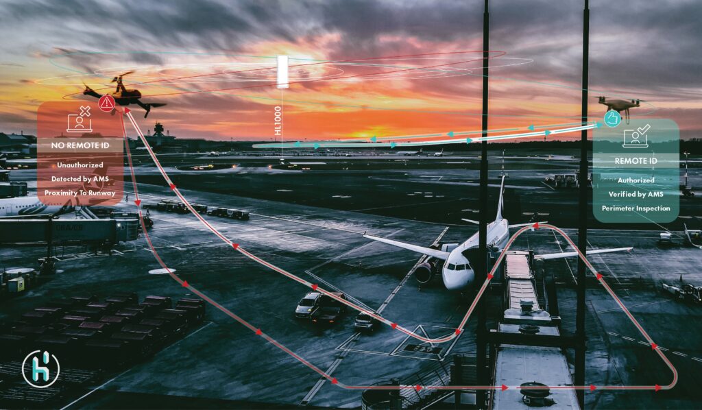
Drone sensing company Hidden Level has developed a technology called the Airspace Monitoring Service, or AMS, which can be used to track Remote ID. Hidden Level’s AMS solves two potential problems with the Remote ID system—drones that fail to broadcast information and those that broadcast false Remote ID information.
Last year, Hidden Level’s team deployed its AMS for evaluation by the FAA as both a standalone solution and a complementary technology for Saab’s SAFE Airport Event Management system. In an announcement this week, the company confirmed that it will continue to support the FAA’s Airport Unmanned Aircraft Systems (UAS) Detection and Mitigation Research Program.
Hidden Level collaborates with NASA’s Ames Research Center to evaluate the use of its Airspace Monitoring Service for drone traffic management. The company is also a partner of Joby Aviation, a developer of electric vertical take-off and landing (eVTOL) aircraft.
Hidden Level’s CEO Jeff Cole recently shared his thoughts with Avionics International on Remote ID technology, the safe integration of drones into the airspace, and the advantages of their AMS. Check out our question-and-answer session with Jeff Cole below.
Avionics: Can you share some background about the company?
Jeff Cole: The existing air traffic system and surveillance infrastructure that’s been in place for decades to monitor manned aircraft was never designed for this low-altitude mission over cities, where we’ll have to monitor potentially hundreds of drones and urban air mobility vehicles.
Hidden Level was created about four and a half years ago. Our focus was bringing disruptive technology to the industry in a disruptive business model.
How do we bring some really cutting-edge technology to market and provide performance and access to it? That’s our airspace monitoring service, which is the cornerstone of our product offering. We’ve built this technology that we own and maintain, and we deploy it on existing infrastructure such as rooftops and cell towers. The focus is on blanketing low-altitude urban airspace to monitor manned aircraft and drone traffic to help scale and enable advanced air mobility initiatives—drone delivery, urban air mobility—while at the same time addressing security and safety concerns.
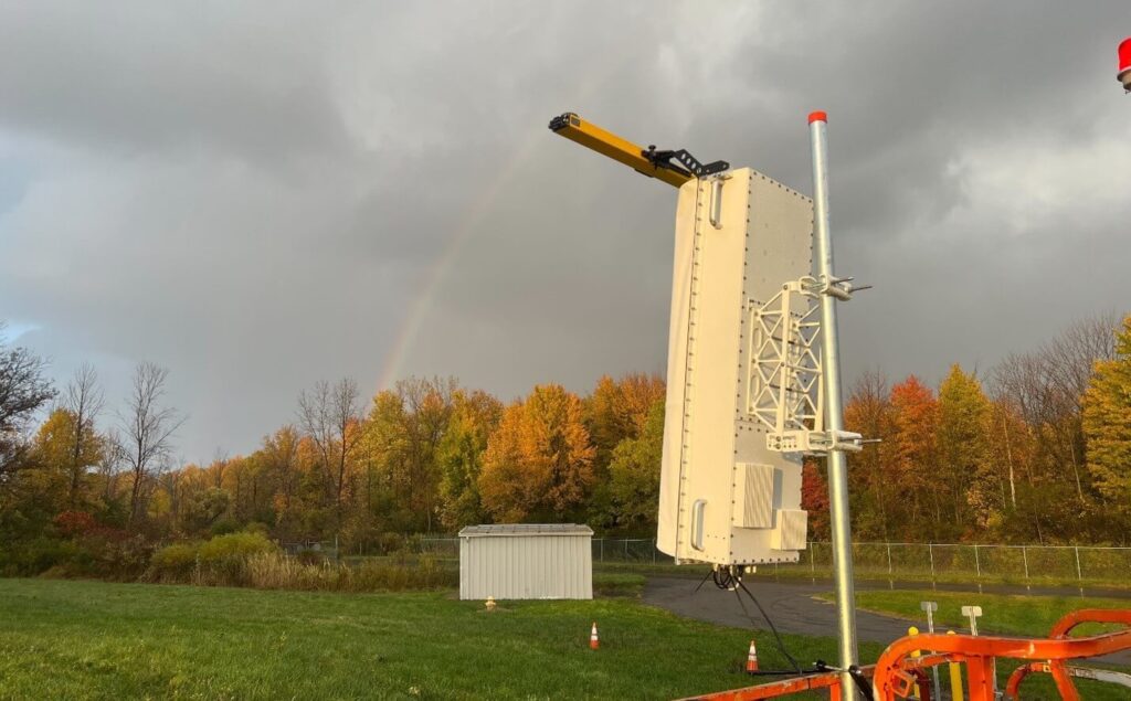

Hidden Level HL1000 sensor installation at Syracuse Hancock International Airport (Photo: Hidden Level)
Could you tell us more about how Hidden Level’s Airspace Monitoring Service technology works and how the AMS verifies Remote ID signals?
Cole: The technology is completely passive in its capability and is also privacy-compliant. A lot of passive technologies will demodulate or pull signal information and grab location from the signal. Our technology works very differently. It is able to hear a signal and then triangulate where it is.
If you are in a room with 100 different people and they are all speaking different languages, rather than understanding French, and hearing the French person say, “I’m over in the left corner of the room,” we pick up and say, “That’s a French-speaking individual, I can tell by the phonetic characteristics. I can’t understand what they’re saying, but I can hear them, and they’re actually over in the left side of the room, or the right side of the room. That’s where it’s really synergistic to the Remote ID aspect.
Remote ID is meant to be like an identifiable license plate and a transmission of where you are. If I’m a drone flying around, I’m saying, this is my GPS location and here’s my license plate. We get that information and also detect where it is by hearing a signal in space and we verify and validate that the target is real, the position being reported is accurate, and it’s not spoofed. If you just relied on that signal telling you where it is, you don’t know if it’s actually there. We look at the phonetic characteristics of waveforms in space, we look at the GPS position being reported, and confirm that position is currently accurate and real. That is the Remote ID verification and validation part, which is very different than anything else out there.
There are a lot of different systems that can receive Remote ID. We are a broad frequency solution. We are really built for evolution. As we scale, the technology potentially moves into other frequency areas, we’re still able to detect, verify, and validate those positions.
Have there been any recent trends in what the company’s clients are concerned about or what problems they hope to solve?
Cole: On the security side of things, once you show them the amount of traffic out there, that triggers a lot of concern. How do I get the data in a privacy-compliant manner, and how is this technology scalable for the future as things start to move into 5G or different aspects of the spectrum based on what the SEC may allocate? They want to know that ultimately, this isn’t just a solution for today—they want to know how it is a solution for tomorrow.
When it comes to the advanced air mobility side, it’s being able to see where all of the different drones are and also seeing where manned aircraft are. That’s another aspect of our system; it has the ability to do passive detection of manned aircraft in a pretty unique way. That’s a really key aspect of enabling the future of drone delivery, urban air mobility: How do we scale technology that has the ability to see manned aircraft and drones in a cost-effective manner?
Our airspace monitoring service is a really disruptive offering. We make it accessible and affordable for people because we’re able to share that across a lot of different users and monetize across a lot of aspects of the business versus just selling a piece of hardware for that purpose.
Customers are asking how the data gets to the FAA or somewhere else. If I sold them a piece of hardware to do that, they’re now responsible for that data. The AMS can integrate into all of the different parties that need that information to work in harmony. When it comes to a security mission, for example, you might have a stadium, a first responder or officer, and potentially an agency that’s involved, depending on what’s happening or the severity of the event. Each user has different operations to work in. Our data can integrate into each one, and they can work in harmony quicker and reference the same information.
When it comes to advanced air mobility, our data can feed into different types of services that are doing detect and avoid, or providing that information to air traffic control, et cetera. We needed to make something that is scalable and accessible to everyone at the same time.
 :
: