Several companies developing next generation technologies for drones exhibited their solutions at the fourth annual UAS Public Safety Summit last week. The summit was focused on applications related to public safety that enhance capabilities for law enforcement and first responders.
Solutions presented at the summit included detect-and-avoid technologies, a module that tracks cell phone signals for search and rescue missions, and a platform for public safety officials to publish safety advisories about drone operations.
Hidden Level, headquartered in Syracuse, New York, specializes in low-altitude drone sensing software. The company offers a cloud-based solution, the Airspace Monitoring Service (AMS), to process data from sensors to track drones in real time. According to the company, its technology can detect the movements of more than 95% of commercially manufactured unmanned aerial vehicles (UAVs).
Hidden Level’s team has collaborated with NASA’s Ames Research Center to evaluate use of the AMS for drone traffic management applications and advanced air mobility (AAM) services. Hidden Level’s sensors enabled monitoring of both cooperative and non-cooperative low-altitude airspace traffic at Moffett Federal Airfield. The AMS data can also support research efforts related to airspace characterization; enable safe take-off and landing at vertiports; and monitor flight conformance.
Hidden Level is also involved in a partnership with Joby Aviation, developer of electric vertical take-off and landing (eVTOL) aircraft. The companies share their expertise in designing scalable airspace operations, relying on data collected by Hidden Level’s sensors installed in dense urban environments.
“We offer drone detection as a service,” explained James Licata, VP of Strategy and Partnerships at Hidden Level. “We build our own sensor technology and install it ourselves on rooftops and cell towers, typically in metropolitan areas, to cover as wide an area as we can,” he told Avionics International during the Public Safety Summit.
The AMS collects data on any drones operating in a given airspace and shares that data with agencies such as local law enforcement or corporate security. Hidden Level installs the technology and maintains it, and provides a data feed to the agency.
According to Licata, the company’s current focus is expanding its network to new cities. He noted that they have expanded coverage in the Northeast, and have installations in Mountain View, California, as well as Dallas Fort Worth. “We’re also working on some FAA initiatives,” he mentioned. “It’s been a lot of growth over the past year—we’ve doubled in size.”
Echodyne, a company that designs and manufactures radars for a range of markets, also exhibited its radars at last week’s UAS Public Safety Summit. The radar combines proprietary MESA radar technology with advanced software to detect and avoid objects in the airspace such as birds, drones, and other aircraft. It detects not only location and speed but also altitude, size, and range.
Leo McCloskey, VP Marketing for Echodyne, told Avionics that the company is constantly updating its radars through software. “Detecting and tracking small, fast aircraft in the airspace is both a new and difficult challenge,” he said.
“What Echodyne contributes is a breakthrough technology that shatters the price performance barrier to bring advanced radars that meet the challenge of airspace situational awareness. Our radar technology is essentially the same ESA [electronically scanned array] radar that is found in the nose of fighter jets. Radar technology is almost required to deal with the volumes of drones predicted over time.”
Some of the use cases include putting Echodyne’s radars on tethered quadcopters, autonomously flown vehicles, and fixed-wing aircraft. For public safety applications, the radar’s software allows the users to customize the performance to the location, mission profile, or other requirements.
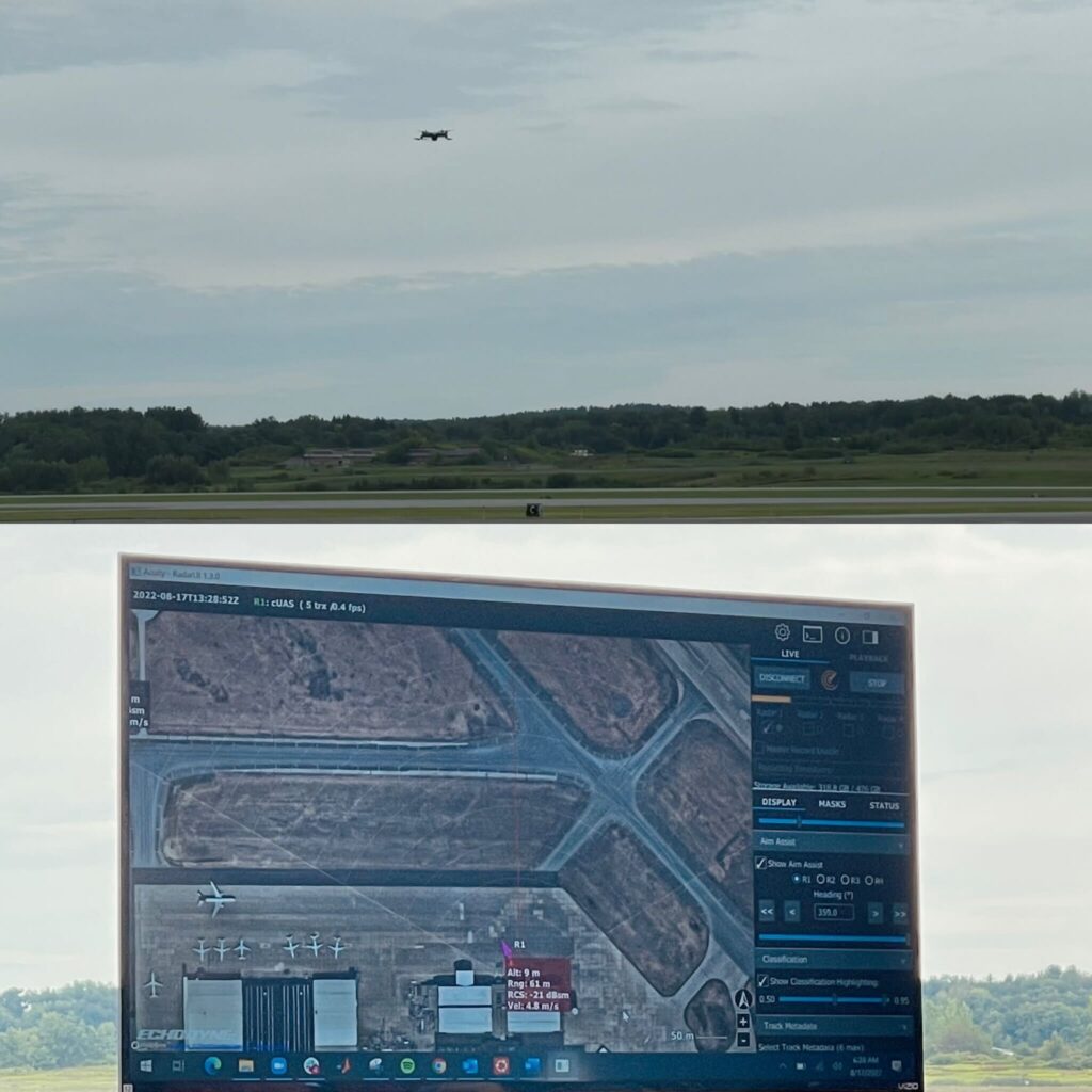
A live demonstration of Echodyne’s software at the UAS Public Safety Summit (Photos: Jessica Reed)
Echodyne radars can detect any object moving in the airspace, regardless of the drone’s configuration or capabilities. The radars are widely used by U.S. Government Agencies for security and surveillance and by a number of UAS test centers and FAA and NASA test scenarios. An example is a $20m IDIQ contract awarded to Echodyne by the U.S. Department of Homeland Security. As the new technologies mature, they will be used more widely by state and local public safety agencies.
“Our radar is going to see everything that moves in the airspace, including the rotors on hovering drones,” McCloskey mentioned. The range of detection varies by product and use case. EchoGuard radar will track small drones at 1 km and large aircraft, like helicopters and Cessnas, at 2.5 km.
Each radar panel offers 120 degrees azimuth by 80 degrees elevation in coverage, with 4 panels providing very robust hemispherical coverage for events and portable use cases.
A new company called Flyhound, which also participated in the UAS Public Safety Summit, is set to launch its solution in October. Flyhound makes a module that can attach to a commercial drone and detect cell phone signals. The solution was originally designed with search and rescue missions in mind, said Manny Cerniglia, CEO and founder of the company.
Flyhound’s module can help first responders during or after a natural disaster like a flood or tornado to locate survivors that may still be in their homes. According to Cerniglia, they are considering a version of the technology that tracks specific individuals. The module would attach to a firefighter’s equipment, for example, to detect their location inside a building and assist them more quickly.
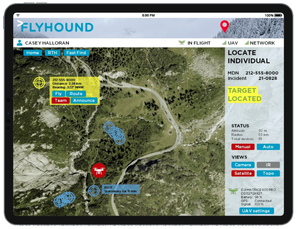

Flyhound’s module is attached to a drone and tracks cell phone signals to quickly locate individuals for search and rescue operations. (Photo: Flyhound)
Another company at the summit that demonstrated its solutions for drones was Aloft. Aloft powers the Federal Aviation Administration’s drone safety app, B4UFLY. The app allows recreational and commercial drone operators to check the airspace before taking flight, and it provides alerts regarding active airspace advisories.
Aloft launched Geo Portal, a free tool for publishing safety advisories related to drone operations, in May this year. The platform supports both permanent and temporary advisories, according to CEO and founder Jon Hegranes, and operators can also schedule future advisories. The Aloft Geo Portal was developed for use cases such as firefighting, public events with special drone rules in effect, and operations in areas with relevant local drone regulations.
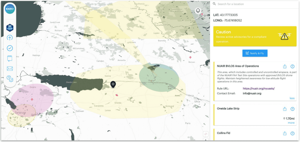

Aloft Geo Portal was launched earlier this year as a free tool for publishing safety advisories. (Photo: Aloft)
“About a third of Geo users are law enforcement or first responders,” Hegranes remarked.
One unique feature of the app is called Notify & Fly. This allows operators to anonymously announce to other drone pilots that they are flying in a particular area, increasing situational awareness as more drones are integrated into the national airspace—without sacrificing privacy, according to Aloft.
 :
: