Commercial

Garmin Pilot App Updated with Real-Time Engine Monitoring

Garmin Pilot engine monitoring on iOS. (Garmin)

Garmin International is adding new features to the Garmin Pilot mobile app. New functions include wireless real-time display and play-back of engine data via Flight Stream 510 and a document viewer that provides easy access to the Garmin aviation library.

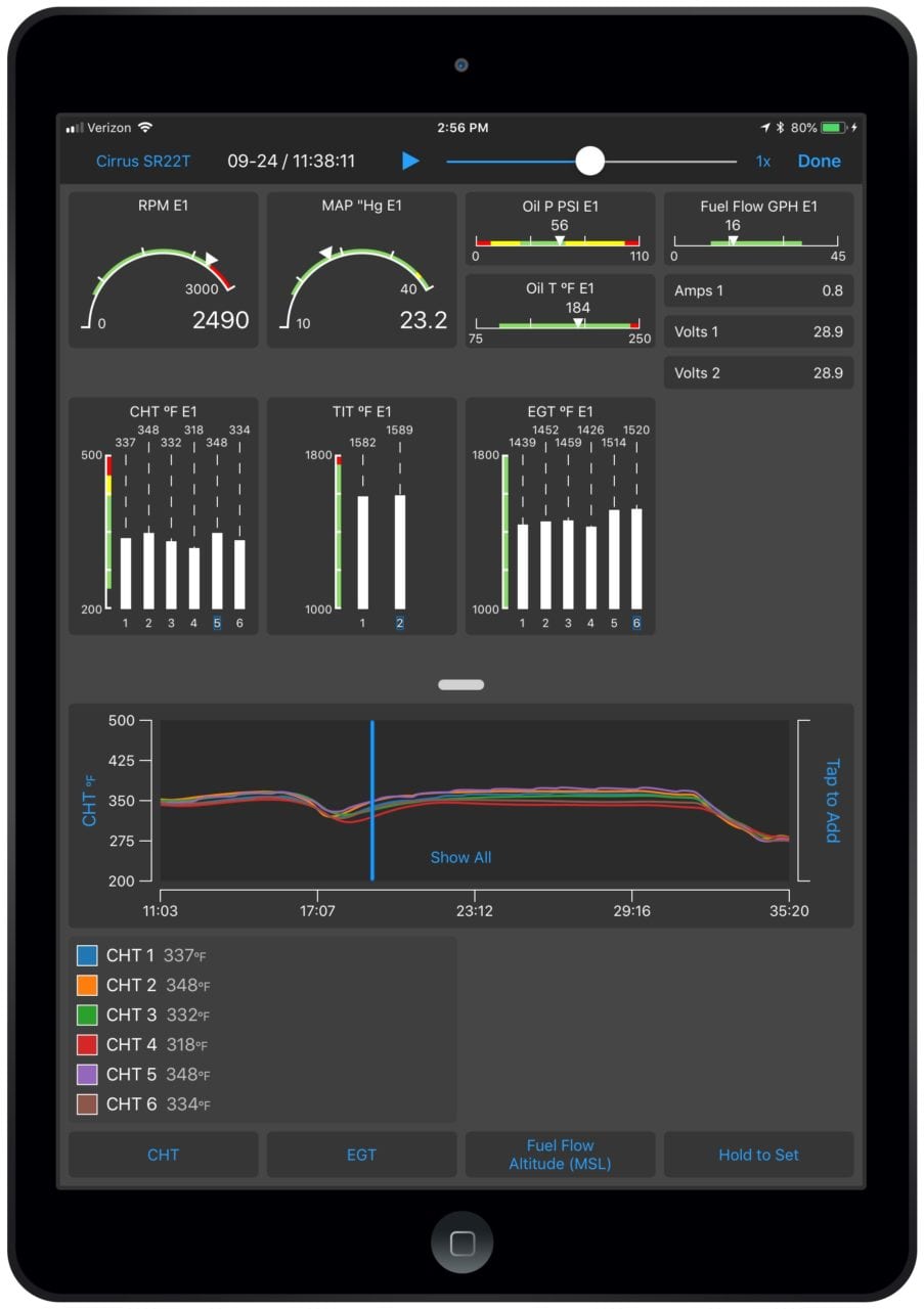
Real-time engine performance and trend data is available when the app is paired with an EIS-capable TXi flight display or the G1000 NXi-integrated flight deck. Upon landing, the flight data log is wirelessly uploaded to the flyGarmin website and is stored securely within the app and on flyGarmin. Within the flyGarmin website, pilots can access detailed information related to any flight, play back the flight and download data logs. Pilot-configurable exceedances can also be set within the flyGarmin website. In the event an exceedance occurs, pilots can receive an email alert.

The new document viewer within Garmin Pilot helps pilots better organize and access a variety of informational products, including the latest Garmin library of manuals such as pilots guides, cockpit reference guides and aviation handbooks. The premium version of Garmin Pilot allows customers to access popular cloud storage sites like DropBox.

Additional updates are coming depending on whether the app is used on Apple or Android.

For the Apple version, the enhancements are expected to include:

  • Pilots can view the Area Forecast Discussion (AFD) within Garmin Pilot, which is a plain-English narrative developed by meteorologists at the National Weather Service.
  • Model Output Statistics (MOS) are accessible within the app, which displays a forecast similar in format to the Terminal Aerodrome Forecast (TAF). The MOS is updated hourly and the forecast extends 72 hours into the future.
  • Within the U.S. and Europe, pilots can view base reflectivity radar, which utilizes the lowest elevation scan to display precipitation falling from the clouds better than other radar scans.
  • Pilots can create a custom map shapefile on a computer to design a customized map so it’s easier to reference their position relative to a specific geographic area, such as a practice area. This map file is transferred from a computer via email and then uploaded within the app.

Enhancements to the Android version are expected to include:

  • Storm cell movement displays the projected path of a storm. An orange circle paired with a line that extends from the strongest storm cells shows its potential path in 15, 30, 45 and 60-minute intervals. If hail or tornadic activity is present, a corresponding icon will also be displayed alongside the particular storm cell line.
  • Pilots can also view the Area Forecast Discussion (AFD) that is disseminated in a plain-English narrative within the app.

Receive the latest avionics news right to your inbox