 |
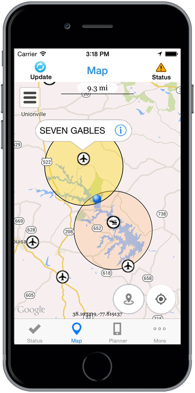
| B4UFLY mobile application. Photo: FAA |
[Avionics Today 05-07-2015] The FAA has announced a smartphone application that aims to make it clear to Unmanned Aerial Vehicle (UAV) enthusiasts where it’s legal to fly in the National Airspace System (NAS). The B4UFLY app, announced at the 2015 Association for Unmanned Vehicle Systems International (AUVSI) Conference in Atlanta, Ga. taking place this week, will allow hobbyists to determine whether there are any restrictions or requirements in effect at the location where they want to fly a UAV.
“It’s a simple, easy-to-use app that answers a very basic safety question: is it safe and legal to fly my unmanned aircraft at a particular location?” FAA Administrator Michael Huerta explained to journalists during a press conference for the roll out of the new app. “Longtime members of the unmanned aircraft community may already know the answer to that question. Someone who got their first unmanned aircraft as a gift under the Christmas tree probably doesn’t. That’s a knowledge gap we need to fill.”
The agency is planning to release the app to an estimated 1,000 beta testers during the summer. Limited beta tests are expected to run for several months, after which the FAA will make the app available to the general public on Apple iOS devices, with an Android version to follow.
The app features interactive maps and a clear status indicator that immediately informs the operator about the area surrounding their current or planned flying location. For example, it would indicate that flying in Special Flight Rules Area around Washington, D.C. is prohibited and other similar restricted flight areas. It also provides information on such parameters that may restrict airspace, contact information for nearby airports and links to other FAA UAS resources and regulatory information to keep operators updated to the fullest extent.
“We need to make sure hobbyists and modelers know where it’s okay to fly and where it isn’t okay to fly — because there can be very real consequences if you don’t. The incident on the White House lawn earlier this year is a good example,” Huerta said, referencing an incident in January in which a hobbyist’s small quad copter crashed onto the front lawn of the president’s residence, inflating the push amongst lawmakers for drone regulation across the NAS.
The FAA is slowly making progress toward full scale UAV regulation, having revealed its highly anticipated Notice of Proposed Rule Making (NPRM) for small commercial UAS in February. With the public comment period recently closing on the NPRM, ringing in just under 4,500 comments, a final rule is expected sometime in the next 18 months — although Huerta has expressed he would like to see publication of the final rule later this year. The FAA’s limited resources to review and approve the final rule are expected to slow the progress, however.
In the meantime, the new app is just one in a series of campaigns to encourage responsible use of unmanned aircraft, including the FAA’s recent partnership with other UAS organizations, such as the Academy of Model Aeronautics (AMA), the Small UAV Coalition and AUVSI to launch the “Know Before You Fly” Campaign.
Huerta notes that similar resources for UAS operators are emerging, but believes that the B4UFLY app will make it easy for users to access information direct from the FAA.
“Technology has made it so that almost anyone can operate an unmanned vehicle without any prior aviation experience,” said Huerta. “At the same time, technology also provides us with an opportunity — to give these users the tools and knowledge they need to operate safely before they fly.”