Malaysia Airlines’ Flight MH370 is not the first aircraft to disappear and leave the public in the dark about what happened for months and even years on end. Air France’s Flight 447 disappeared, then crashed in 2009, but it was two years before the Brazilian Navy found the 228 bodies and wreckage. That same year, the Coast Guard lost a Hercules C-130 after it collided with another aircraft off the coast of California — and it has never been found.
“Who are the people who look for missing things? It’s the Coast Guard. You think they allowed that to happen without a pretty thorough search? That they lost an entire aircraft and their comrades have never been found?” asks Keith Masback, CEO of the Geospatial Intelligence Foundation.
In between takes during the filming of a Discovery Channel documentary on the MH370 disappearance, Brian Weeden, technical analyst at the Secure World Foundation, discussed the facts with peers in the Green Room. In those conversations with pilots and Air Traffic Controllers (ATCs), Weeden says no one was able to come up with a theory that could make sense of each piece of data from satellite imagery, radar, and aircraft data transmissions. “Even among the experts,” says Weeden, “there’s multiple theories about what happened and there’s still not 100 percent certainty over exactly what happened.”
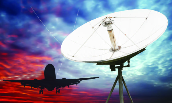
Following the data released after MH370’s disappearance, the industry seems determined to take better action once and for all. The International Aviation Transport Association (IATA) Director General Tony Tyler called for better aircraft tracking; and the European Aviation Safety Agency (EASA) followed with a proposal that cockpit voice recorders capture 20 hours instead of two, and that “obsolete recording technologies” be replaced by Jan. 1, 2019. The EASA proposal also called for better batteries for Underwater Locator Devices (ULDs) that allows these to record for 90 days instead of 30 days, effective after Jan. 1, 2020. This proposal gained full support from the International Civil Aviation Organization (ICAO), which then held the Multidisciplinary Meeting Regarding Global Tracking in Montreal, ahead of which Inmarsat proposed a service called SwiftBroadband Safety to ICAO and IATA. The proposed service periodically offloads position location from the cockpits of the world’s long haul commercial SwiftBroadband-equipped fleet free of charge. Inmarsat’s proposal also included a “black box in the cloud” service in which defined trigger events, such as course deviation, automatically trigger streaming of historic and real-time flight recorder data. Flyht provides a similar service with AFIRS, a real-time emergency-triggered flight data streaming system. Both Inmarsat and Flyht presented on their products for IATA’s Aircraft Tracking Task Force (ATTF) June 11-13 although, as of the time of publication, IATA had yet to release an improved standard.
Ever since Air France Flight 447, the Airlines Engineering Electronic Committee (AEEC) has been working on the longer-range, lower frequency ULBs EASA has proposed.
Robert Swanson, manager of aircraft avionics engineering, navigation and surveillance at FedEx Express and chairman of the AEEC Low Frequency – Underwater Locator Beacon (LF-ULB) Working Group, says that even though the LF-ULB is a positive step toward locating future crashes, what really needs to happen is simple. “Just being able to know where the plane is. You just need to have constant updates of where the plane is, regardless of what anyone on the airplane does,” he says.
Weeden thinks the same thing. “The big question in everyone’s mind is ‘should the flight data, or some portion of it be live streamed?’” According to Chuck Horning, associate professor and department chairman of Aviation Maintenance Science at Embry-Riddle Aeronautical University, aircraft tracking in real time all the time is also the definitive solution. “I think probably [that’s] number one, just so that you know where the airplanes are constantly,” he says. “Right now, the technology is there to do this, but the ability to do it is not there. The [existing operational] satellites may not currently be able to handle the amount of data, and the infrastructure just isn’t there to integrate the information with Air Traffic Control (ATC),” says Horning.
While there may not be enough spectrum for large amounts of continuous data offloading, basic continuous position location is feasible now. The only thing standing in the way of ensuring something like this never happens again, that we always know where our aircraft are, is a mandate. “Certainly the technology to provide basic position reporting is well established [and] proven today. … But a lot of work needs to be done in order to enable these kinds of applications, a lot of parties have to come together,” says John Mackey, senior vice president of network operations at Inmarsat. Aircraft and avionics manufacturers, airlines and regulators will all need to do their part, he says.
Even though Inmarsat has offered position location services for free to airlines, installation is not likely without a mandate, according to Weeden. “The question would be how to incentivize airlines to start doing it, and whether or not there’s a cost benefit tradeoff. There’s only been two of these cases in the last few years, and yet there’s upwards of 90 million plugs a day. I have not run the cost numbers, but it’s probably going to be a not-insignificant amount of money to find two aircraft. That’s a really hard decision to make. … You know the decision that your heart tells you to make; but is that the decision that companies are going to make, and the government is going to make? I don’t know,” says Weeden.
It’s not bad press that airlines care about either, according to Swanson. They just care about what makes the airplane safer and what serves customers better, and knowing where the aircraft is doesn’t change what happens to it, he points out. Jacob Barak, director of engineering at EL AL Israel Airlines, is a perfect example of Swanson’s observation. “I think that [satellite communications] (satcom) basically will enhance the company operations, the communication with the ATCs at any given time. It has a good input to the safety but it’s not a key solution for the safety priority. As an engineer, I believe in the hardware and software of the aircraft and the components,” says Barak. His point is that though satcom might give the public peace of mind, it doesn’t make the aircraft safer and it is the avionics systems themselves that determine whether the plane is safe. Everything else is about human error, and no amount of ground communication can prevent a fatal unexpected incident.
Contact Loss
Contact loss actually occurs all the time without fatal results, says Neill Fulbright, associate program coordinator of the Avionics Line Maintenance Program at Embry-Riddle Aeronautical University. “Terrestrial radar … lose site of airplanes. They do it all the time over water, just like it happened with the Air France Flight 447,” says Fulbright. When ATC is unable to locate an aircraft by use of the secondary radar — in which a signal is sent and the transponder must squawk location back — the military can detect whether there are at least any objects in the vicinity by use of primary radar. If secondary radar is unable to locate the plane due to weather, distance or a non-responsive transponder, then primary radar cannot identify the lost plane; it can only reveal whether there are other objects in the vicinity of the airspace in which the flight was lost.
After radar contact has been lost, says Fulbright, “What you’re left with is two forms of communication: one of them is high frequency communication [radio], which can be unreliable, and the other is satellite communications.” Though High Frequency (HF) radio is notorious for its unreliability, ACARS doesn’t rely only on HF to transmit locations; typically it can also send signals using Very High Frequency (VHF) and satcom, both of which are available across almost the entire globe, “dead areas” excepting, says Chuck Horning, department chairman of aviation maintenance at Embry-Riddle Aeronautical University.
In the case that the transponder has been turned off, ACARS is there to keep contact. But the problem, says Horning, is that ACARS is not as hard to disable as some have said. “For all the airplanes that I worked on, [ACARS] wasn’t very difficult [to disable] if you had the knowledge about the aircraft. … it wasn’t difficult on large commercial Boeing products, Airbus, mainly Boeing [recent models],” he adds, admitting that shutting off ACARS is as easy as flipping a circuit breaker at home.
While global connectivity from the likes of any mobile satellite service provider such as Globalstar, Iridium or Inmarsat can provide real-time updates to Electronic Flight Bags (EFBs), allow real-time telemetry information from aircraft, and even allow downloading of flight recorder data, the avionics systems already in place are highly reliable.
The reality is that real-time position reporting, though possible now, won’t happen until customers demand the service for their peace of mind, or until the costs come down. According to a Reason-Rupe poll on Americans’ views of commercial Air Transport (AT) following the loss of MH370, only 17 percent of respondents said they would be less likely to fly because of the tragedy. According to Mackey, the equipment and antennas required for position broadcast via satcom is getting smaller and cheaper. “[The] antenna would be about 24 inches long, that allows it to be used on a wider variety of aircraft than it is today, including business jets,” he says.
Inevitability
Michael Small, CEO of Gogo says real-time location is inevitable, but not immediate. “It is inevitable that location will be real-time, no one [will be] searching for a Black Box a decade from now. It will be measured in years before that is universally true but I would say a combination of having a lot of network choices, but we will also be reaching a lot of aircraft. We have over 2,000 commercial jets and 2,000 business jets,” he says.
Even with ICAO, EASA, IATA and the Federal Aviation Administration (FAA) movement on the issue, a mandate will take effect at least a few years into the future, if at all, and the decision will be left to the business and hardline safety case. Airlines will run the numbers on whether continuous position is a better investment in safety than trusting highly reliable critical systems and procedures.
For now, we are left with 239 missing bodies and thousands of aircraft that every day takeoff and fly across the oceans, checking in at scheduled times only, remaining ultimately out of site, and too often, out of contact.